
Uki, Mount Warning, NSW, 2484
Head in the Clouds
by Jo-Ann Palmer.
 Founded on timber getting and dairying, Uki (pronounced yook-eye) is a beautiful and peaceful village located virtually at the foot of Mt Warning, with the name believed to be derived from the aboriginal name for a water fern with edible roots.
Today Uki is a community based on dairying, with a developing base of tourist accommodation and expanding residential small acreage.
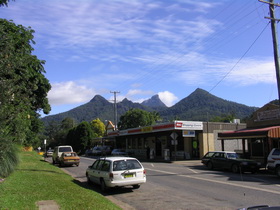
Uki main street © D Palmer, Big Volcano
Situated on the southern arm of the Tweed River, just about anywhere in Uki will provide you with stunning views of Mt Warning and ring dykes commonly known as "the 3 Sisters".
Big Volcano Supporters
Accommodation in Uki, Mt Warning and nearby
Hint: Mouse over for external site description. External links open in a new window.
Hosanna Farmstay

Accommodation Directory
More Accommodation
Book direct via Booking.com from the links below
EcOasis Resort
- A View Of Mt Warning B & B
- Chesson Lodge New
- Gymea Eco Retreat & Day Spa
- La Rocher Eco Retreat
- Mavis's Kitchen & Cabins
- Mt Warning Forest Hideaway
- Mt Warning Rainforest Park
- Mt Warning Rainforest Retreat
- Nalini Retreat
- Shambala at Uki
- Big Volcano Accommodation Directory
Local Tours & Attractions
Hint: Mouse over for external site description. External links open in a new window.Activities and Attractions Directory
More Tours & Attractions
- Uki Events
- Bird Watching Walks in the Tweed Valley
- The Big Climb - Mount Warning Summit Walk
- Mount Warning Gliding Adventure Slideshow
- Wollumbin (Mount Warning) National Park
- Battle of the Border Cycling Festival - June
- Clarrie Hall Dam
- Community Technology Centre @ The Buttery
- Curl Up and Dye Aveda concept Hair and Beauty
- Guinea Stall, Murwillumbah - Kyogle Rd
- Gymea Eco Retreat & Day Spa
- Esther & Cameron Handmade Uki
- Mavis's Kitchen
- Rainforest Cafe - Mt Warning
- Uki Cafe
- Uki Creative Arts Gallery
- Uki Pies
- Uki Takeaway
- Vibrant Imaging
- Big Volcano Activities & Attractions Directory
Accommodation
Lodgings in the village and surrounding area cater to a wide range of accommodation options, from affordable camping grounds and cabins, B&Bs, guesthouses, homestays and motel style accommodation, through to luxury couples only villas.
Attractions
The village has been a listed Conservation Area since 1987, with heritage buildings including the old Convent, the old Bank Building and the old butter factory, now known as "The Buttery" and converted to art and craft galleries and artisans workspaces.
Outdoor picnic tables are dotted around to sit down and enjoy a delicious Uki Pie (made with love), while you admire your latest home decoration purchase from Esther & Cameron Handmade Uki, Antiques & Vintage at Uki or other local art and craft outlet inhabiting the building.
The Uki Community Technology Centre, provides office and secretarial services, internet access and training.
Uki Markets
The weekly weekend farmers market and monthly market bazaar fill the area surrounding the Buttery with fresh produce stalls from local farmers and local traders.
Across the road from the Butter Factory, the Uki Cafe - a favourite for locals, offers a diverse menu based on locally sourced organic produce, with vegetarian, vegan and gluten free offerings available.
The historic Mt Warning Hotel burned down in 2013 and has now been rebuilt, with ample parking for local patrons, and visitors recovering from a Mt Warning climb, or visitors on a scenic weekend drive, looking for a friendly country pub to enjoy a break.
A number of landcare projects are replacing exotic creekbanks species with native trees and shrubs in a number of locations, including a project for a Uki Riparian Corridor and Platypus Walk. A rainforest walk along the Tweed River (south arm), is accessible behind the Butter Factory.
And if you go bats over Flying Foxes, a colony might be found adjacent to the bridge on the southern side of the village.
Picnic facilities including B.B.Qs, are abundant at Clarrie Hall Dam, south of Uki.
The World Heritage listed Wollumbin (Mt Warning) National Park is less than 10 minutes drive, and Nightcap and Border Ranges national parks make for a pleasant full day driving tour.
If you are in Uki you are in the middle of it!
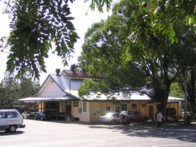
Uki Buttery © D Palmer, Big Volcano
Mt Warning Road
Mt Warning Road is on the way to Uki, and just 10 minutes drive from Murwillumbah.
It not only leads to the World Heritage listed Wollumbin - Mount Warning National Park, but along the way also features roadside produce stalls, and if you'd prefer some fine dining, the Rainforest Cafe or Mavis's Kitchen.
Available accommodation includes a caravan and camping park, a comfortable and affordable guesthouse, and exclusive B&B retreats where you can enjoy the natural environment in total luxury.
Dreamtime Stories
The Nganduwal people have many Dreamtime stories handed through the generations, with more than one legend attached to "Wullumbini Momoli" / Mount Warning / Wollumbin, and how its name came to be.
Some people say Wollumbin means cloudcatcher or weather-maker; others say it means turkey or Warrior Chief. Here are two stories.
Wollumbin – The Turkey
Once, a long time ago, turkeys could fly greater distances than they can today. Well, one turkey flew from Mt Brown. He had joined a gathering of other birds talking, when a giant bird approached. All the birds, the turkey too, were so frightened they flew away quickly.
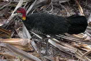
Brush turkey © D Palmer, Big Volcano
The turkey flew all the way to Wollumbin, and stopped on the top of the great mountain to catch his breath. But as he rested, he was wounded in the head by a spear from a warrior.
Because of his head wound, the turkey's flying ability was impaired.
That is the reason why turkeys today can fly only short distances before they must rest; and if you look at Wollumbin you can see the mountain top has a small bend in it where the spear hit the turkey. The mountain tip is the point of the warriors spear.
Wollumbin – The Warrior Chief
The word, Wollumbin, is also said to mean warrior or fighting chief of the mountain.
Legend has it that the spirits of the mountains were warriors. The wounds they received in battles are the scars on the mountainside, and the thunder and lightning are the results of their battles.
If you look today towards Wollumbin from certain angles, you will see the face of the warrior chief in the mountain outline.
Wollumbin is a central sacred site for neighbouring tribes, as well as for the valley tribes. There, special tests were conducted for the men who wanted to become clever men. Not all men were allowed to climb to the suummit, only the clever men.
Excerpts; P43 (names), and P38 (sacred site), from "Minjungbal, Aborigines and Islanders of the Tweed Valley", by Jolunda Nayutah and Gail Finlay, North Coast Institute for Aboriginal Community Education, 1988 ISBN: 0 7316 2824 1.
Getting to Uki, Mt Warning
Road
Getting here. Uki and Mt Warning are approximately 845 kilometres - about 11 hours drive north from Sydney, via Murwillumbah,
and approximately 145 kilometres - about 90 minutes drive south from Brisbane, via the Pacific Motorway.
Driving options include the Pacific Highway in New south Wales, and the Pacific Motorway from Queensland, via Murwillumbah, and the Summerland Way in New South Wales, via Kyogle.
Air
Domestic flights operate from all capital cities to Ballina/Byron Gateway Airport and Gold Coast Airport at Coolangatta. A number of international carriers servicing SE Asia, New Zealand and the Pacific fly into Gold Coast Airport.
Charter flights may also available to Lismore Airport. All airports have airport car hire or other car rental services available nearby.
Daily airport transfer services between Ballina/Byron Gateway Airport and Gold Coast Airport, are available to selected localities in the region, with some shuttles also going to Brisbane International Airport. Visit Gold Coast Airport Transfer Services for more information.
Coach/Rail
Daily interstate coach services are available from Murwillumbah to Brisbane, Sydney and Melbourne, and daily or overnight train service is available from Sydney to Brisbane via coach transfer at Casino.
Google Ads